Peak Elevation

0 meters above sea level

Located in Nasugbu, Batangas, Philippines, Mount Batulao is a grassy terrain mountain standing at 811 meters above sea level. It offers picturesque views of the surrounding mountains and Batangas coastline, making it an ideal day hike for novice and experienced hikers. The hike is a mix of easy and challenging sections with scenic views of the surrounding mountains, valleys, and the sea. The peak of Mount Batulao is the highlight of the hike, providing a 360-degree panoramic view of Batangas and the nearby provinces. The peak is also an excellent spot to take a break, enjoy a packed lunch, and take in the views before descending back down the mountain.

  • Trail Description

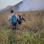
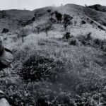
    The mountain has two trails - the old trail, a more challenging route, and the new trail, more beginner-friendly, both offering popular options for hikers and mountaineers. The beginning of the trail is a gradual ascent through grasslands and rolling hills. The views of the surrounding countryside are beautiful, making it an excellent opportunity for nature photography.
    As the trail continues, the ascent becomes steeper, and the terrain becomes rockier. The hiker will pass through several peaks and ridges, with each providing a unique and stunning view of the surrounding landscape. It typically takes around 4-5 hours to reach the peak and back.


    • Trail Length

      3.4 km ( from jump-off to highest peak )

    • Hike Distance

      6.8 km (out and back)

    • Elevation Gain

      440 meters

    • Difficulty Level

      Easy

    • Hazard Level

      Medium (due to exposed and slippery trail)


    Trail Map

  • Directions
    1

    From Manila or Tagaytay

    Ride any bus or van going to Nasugbu, Batangas. Look for the signboard "Nasugbu". Bus terminals: Paranaque Integrated Terminal Exchange (PITX), Buendia and Cubao.
    Inform the driver beforehand that you would like to alight at the road junction near Evercrest Golf Course, where a road leads to Mount Batulao.

    2

    From Evercrest Golf Course Road Junction

    Take a tricycle to the jump-off point of Mount Batulao. One tricycle is good for 3-4 passengers. You may also opt to walk. The jump-off is around 1.5 kms from the junction.

    3

    From The Jump-off Point

    Register and pay entrance fee at the jump-off point. Hire a guide if you need one. Guides are recommended for first-time climbers and those who are not familiar with the trail.

    4

    Start Your Hike

    Start your hike to the peak of Mount Batulao. The trail is divided into 10 stations, and the climb takes around 2-4 hours depending on your pace.

    5

    Reach The Peak

    Enjoy the scenic views from the peak, take photos, and then descend back to the jump-off point.

    6

    Get Back Home

    From the jump-off, take a tricycle or walk back to Evercrest Golf Course road junction, and then catch a bus or a van or a jeep back to Manila or Tagaytay City.

  • Sample itinerary And Expenses

    Example: Solo Hiker


    TimeDetailsEstimated Expense
    5:00 amRide a bus at PITX Bus fare: 200 pesos
    7:30 amETA Evercrest road junction. Take a tricycle (or walk) to the jump-off point.Tricycle fare: 150 pesos
    8:00 amETA Jump-off. Register and pay entrance fee. Hire a guide (if required)Entrance fee: 140 pesos
    8:15 amStart your hike
    10:45 amETA Camp 10 (highest peak of Mount Batulao)
    11:30 amDescend back to Jump-off.
    1:30 pmETA Jump-off. Log-out and pay guide feeGuide fee: 600 pesos
    2:00 pmTake a tricycle (or walk) back to Evercrest road junctionTricycle fare: 150 pesos
    2:30 pmETA Evercrest road junction. Catch a bus going back to Manila or Tagaytay CityBus fare: 200 pesos

    Estimated Total Expense (for a solo hiker)

    0 pesos
  • Tips And Advise

    PRECAUTIONS

    • Slip and trip hazard. The trail becomes slippery and muddy after heavy or continuous downpour and becomes loose soil in dry season. It is important to use appropriate footwear with good traction and to be cautious when traversing slippery trails. Always go slow and low.
    • Fall hazard. Several sections of the trail are exposed and there is a high risk of injury in the event of a fall due to the steepness of the terrain. Adjust your load so there’s nothing protruding from your pack or clothing that can catch on grasses, rocks and terrain features, swing around to pull you off-balance, or in any way get you tangled up. Traversing with your face toward the slope is a good approach. There are roped sections before the peak to help you manage the steep but short section of the trail. Let your guide assist you.
    • Unstable footing. Even the toughest rock will eventually crumble; be sure you're not standing on it when that happens. Look for signs of instability with all of your senses. Look for cracks that could indicate loose rock, or patches of mud or loose soil that could cause you to slip.
    • Extreme heat. Many sections of the trail are exposed with minimal shade. In dry season, you will need to take extra precautions to ensure that you stay safe and hydrated during the hike. It is recommended that you start the hike early in the morning or late in the afternoon to avoid the hottest part of the day. Wear light-colored and loose-fitting clothing that will help to keep you cool. Additionally, it's important to wear a hat or other head covering to protect yourself from the sun. Bring plenty of water ( at least 2 liters ) and electrolyte-rich drinks to keep yourself hydrated, as well as snacks to maintain your energy levels. Sunscreen is also essential to protect your skin from the sun's harmful rays. Take frequent breaks to rest and cool down in the shade if possible. Be mindful of your body's signals and slow down or stop if you feel lightheaded, dizzy, or overheated.


    MONEY MATTERS

    • Cash transactions only.
    • Withdraw cash from ATM's in major cities where they are more likely to be working and well-stocked with cash.
    • Bring cash in smaller denominations (50s and 100s) for convenient transactions.


    TRANSPORTATION

    • Search for the nearest bus or van terminal in advance. You can easily find information about the nearest bus terminals on various online portals or by contacting the bus service provider directly.
    • Check the availability of buses in advance. This will save you from any last-minute surprises or inconvenience that may arise due to unavailability of buses.


    RECOMMENDED BEHAVIORS

    • Respect the locals: Be courteous to local residents by yielding to them on narrow trails and keeping noise levels down.
    • Respect other hikers: Be courteous to all hikers, particularly women, and avoid behavior that may make them feel uncomfortable on the trail.
    • Bring all your trash home: This includes even the smallest candy wrapper and food leftovers. Resist the temptation to throw your trash in any trash bins along the trail or the jumpoff .
    • Stay on marked trails: Follow marked trails and avoid taking shortcuts or creating new trails.

    Learn more about proper behavior when hiking

Leave a Reply

Your email address will not be published.

Comment

Name

Email

Url